A 3 day Lake Tahoe itinerary works best when each day focuses on one section of the lake. For a first visit, stay in South Lake Tahoe or neighboring Stateline. Spend Day 1 on the southwest shore, Day 2 on Nevada’s east shore, and Day 3 exploring Tahoe City and the north shore.
This route covers beaches, trails, historic sites, and several lake communities without requiring a hotel change. It suits late spring through fall, when Highway 89 through Emerald Bay usually remains open. In winter, road closures often require a different plan, so use the seasonal itinerary below.
Start early each day. Parking at Emerald Bay, Sand Harbor, and popular trailheads can fill before 9 a.m. on summer weekends. Lake Tahoe sits above 6,000 feet, so drink water, apply sunscreen, and keep your first day manageable.
How This 3 Day Lake Tahoe Itinerary Fits Together
Lake Tahoe covers more ground than many first-time visitors expect. The 72-mile drive around the lake takes about three hours without stops. Summer traffic can add hours, especially near beaches and two-lane shoreline sections.
This itinerary avoids using the full loop as one continuous sightseeing drive. Day 1 covers the southwest shore, while Day 2 stays on the Nevada side. Day 3 links the west, northwest, and north shores.
South Lake Tahoe and Stateline sit next to each other at the lake’s southern end. The California-Nevada border separates them. Stateline offers Nevada casinos for guests 21 and older, while South Lake Tahoe has more restaurants, lodging, beaches, and daily services.
| Day | Area | Main stops | Driving from South Shore | Bad-weather backup |
|---|---|---|---|---|
| Day 1 | Southwest Shore | Emerald Bay, Eagle Falls or Vikingsholm, Tallac Historic Site, Pope Beach | About 30 to 40 minutes to Emerald Bay in light traffic | Short lakeside walks, seasonal museums, or a relaxed South Shore afternoon |
| Day 2 | Nevada East Shore | Sand Harbor, Tahoe East Shore Trail, Incline Village area, Cave Rock viewpoint | About 40 to 55 minutes to Sand Harbor without heavy traffic | Scenic driving, sheltered shoreline stops, and indoor time in Stateline |
| Day 3 | West, Northwest, and North Shores | Tahoe City, Truckee River outlet, Kings Beach, optional Truckee detour | About 75 minutes to Tahoe City in light traffic | Truckee’s walkable downtown or a shorter South Shore day |
Day 1: Emerald Bay and the Southwest Shore
Morning: Reach Emerald Bay Before the Parking Rush
Leave South Lake Tahoe early and follow Highway 89 north toward Emerald Bay. The drive takes about 30 to 40 minutes in light traffic. Parts of the road are narrow and exposed, so drive carefully and use only designated pullouts.
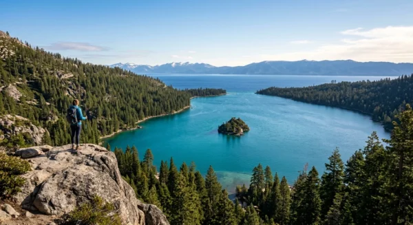
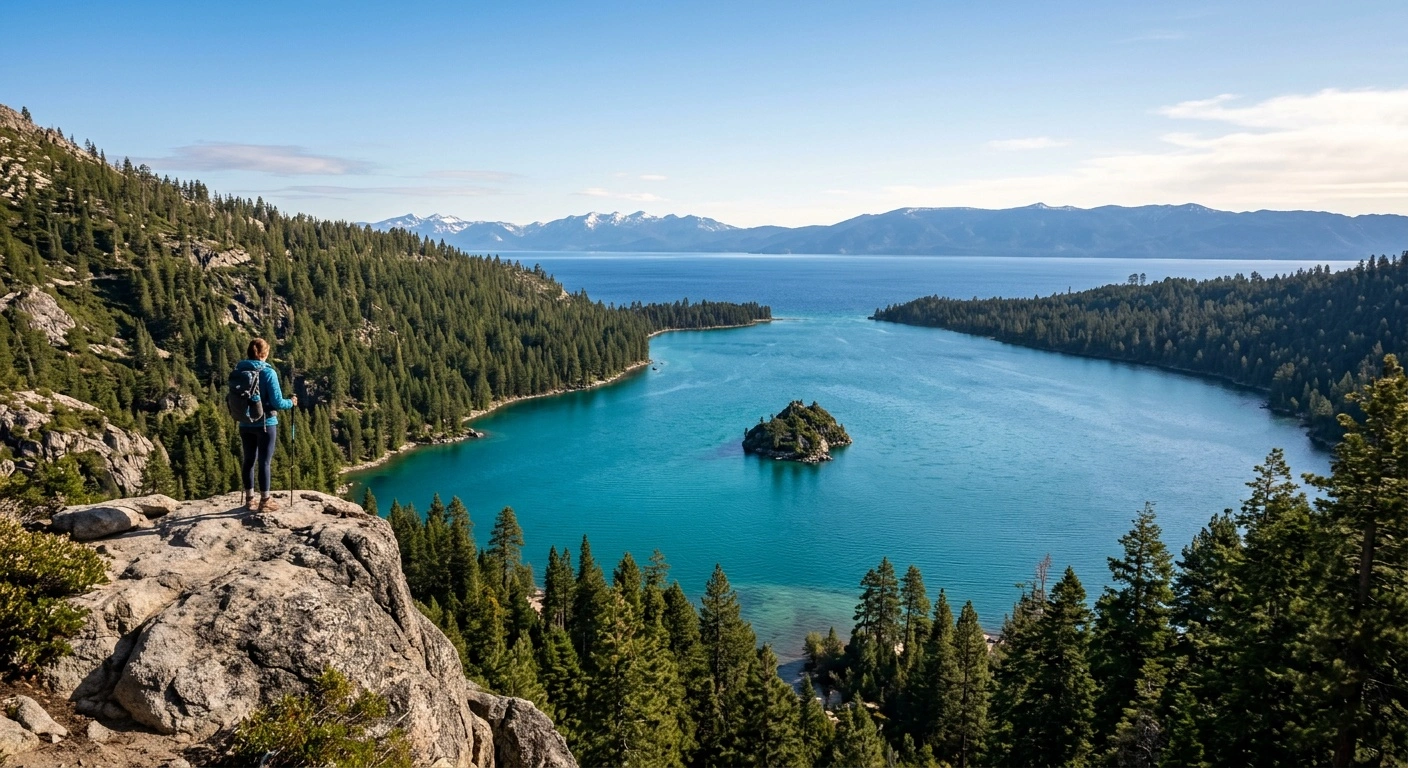
Emerald Bay has a long, sheltered shoreline, steep forested slopes, and Fannette Island near its center. Parking near the main overlooks and trailheads remains limited. On a summer weekend, legal spaces may disappear by midmorning.
For a short visit, stop at the overlooks and view the bay from several angles. For a longer outing, walk down to Vikingsholm, a Scandinavian-style estate at the head of the bay. The trail covers about one mile each way and drops roughly 400 feet.
The uphill return feels harder at altitude. Wear supportive shoes and carry water, even if the trail seems short. Tours and building access operate seasonally, so check California State Parks before planning an interior visit.
Late Morning: Choose Vikingsholm or Eagle Falls
A detailed Vikingsholm visit and a long Eagle Falls hike can make the morning rushed. Choose one as your main activity. Eagle Falls provides a shorter look at granite, forest, and flowing water near Emerald Bay.
Water flow changes throughout the year. Spring and early summer often bring stronger snowmelt, while late summer may have less water. Uneven trail surfaces make the area unsuitable for visitors who need a level or fully paved route.
Trails beyond Eagle Falls enter Desolation Wilderness. Day hikers need the appropriate permit before continuing into the wilderness. Check trail conditions and avoid improvising a backcountry route, particularly when snow remains on shaded slopes.
Altitude can affect visitors soon after arrival. If someone develops a headache, unusual fatigue, or nausea, shorten the hike and return to a lower-effort activity.
Afternoon: Tallac Historic Site, Taylor Creek, and Pope Beach
Drive south on Highway 89 to the Tallac Historic Site. Its former lakeside estates offer a straightforward introduction to Tahoe’s resort-era history. You can walk the grounds, though tours, programs, and building hours change by season.
Nearby Taylor Creek Visitor Center makes another low-key stop when it operates. Short trails cross forest and wetland habitat. In fall, follow all posted parking and wildlife-viewing restrictions around the creek.
Finish at Pope Beach if the weather stays warm. Lake Tahoe remains cold throughout the year, including July. Enter slowly, supervise children, and leave the water before numbness affects movement or judgment.
Developed beaches and recreation sites may charge parking or entry fees. Many also restrict dogs. If rain, smoke, or strong wind reaches the area, return to South Lake Tahoe for an early meal.
Day 2: Sand Harbor and the Nevada East Shore
Morning: Make Sand Harbor Your First Stop
Leave South Shore early and drive north along Nevada’s side of the lake. The trip to Sand Harbor usually takes 40 to 55 minutes without heavy traffic. Along the way, you will pass Zephyr Cove, Cave Rock, and Glenbrook.
Sand Harbor combines sandy coves, granite boulders, and relatively protected water. Access requires planning because the park draws large summer crowds. Nevada State Parks may use reservations or seasonal entry procedures, so check the current rules before leaving.
Do not circle on the highway while waiting for a space. Never park in a prohibited area or along an unsafe shoulder. If the park reaches capacity, follow staff directions and use an approved alternative.
Morning usually provides calmer conditions for kayaks and paddleboards. Everyone on a paddlecraft should wear a properly fitted life jacket and remain close to shore. Clean, drain, and dry personal gear, then review current inspection requirements through Lake Tahoe’s official boat inspection program.
Midday: Walk Part of the Tahoe East Shore Trail
The paved Tahoe East Shore Trail follows Nevada’s shoreline between the Incline Village area and Sand Harbor. It offers broad lake views, granite coves, and several access points. Choose a short out-and-back walk instead of committing to the full route.
Sun exposure and elevation can make the return feel longer than expected. Carry more water than you would for a similar walk at sea level. A hat and sunscreen also help because many sections have little shade.
Cyclists and pedestrians share parts of the trail. Keep right and avoid blocking the path when you stop for a view. Families can focus on a short section, while experienced walkers can continue farther.
Parking near trail access points also fills quickly. Some lots charge fees or enforce time limits. Confirm your next parking option before leaving Sand Harbor.
Afternoon: Incline Village, Cave Rock, and the Drive South
Continue toward Incline Village for lunch or a break from the sun. This Nevada community feels more residential than a compact tourist downtown. Nearby Crystal Bay sits beside the California border.
Some local beaches limit access to residents or pass holders. Check signs instead of assuming every shoreline entrance welcomes the public. Kings Beach offers broader public access farther west, but adding it will extend the day.
On the return trip, stop only at designated east-shore viewpoints. Cave Rock holds deep spiritual importance for the Washoe Tribe. View the landmark respectfully and do not climb it.
Traffic often slows around beach entrances and Stateline near sunset. Allow extra driving time. If wind, thunderstorms, or smoke disrupt the day, return early for indoor dining or entertainment in Stateline.
Day 3: Tahoe City, the North Shore, and Truckee
Morning: Follow the West Shore to Tahoe City
Leave early and drive north on Highway 89 through Homewood, Tahoma, and Meeks Bay. Tahoe City sits on the northwest shore, where the Truckee River leaves Lake Tahoe. The drive takes about 75 minutes when traffic moves well.
Summer roadwork, beach traffic, and slow vehicles can increase that estimate. Use legal pullouts if you want to stop for a view. Never stop in the roadway or block traffic on the two-lane highway.
In Tahoe City, walk near the lake and the Truckee River headwaters before town grows busy. This area also offers coffee, breakfast, fuel, and other visitor services. Smaller West Shore communities have fewer options.
Walkers, cyclists, and seasonal river users share the Truckee River corridor. Rafting access and commercial trips depend on current water levels. Check conditions before building the day around a river activity.
Midday: Choose Kings Beach or Truckee
From Tahoe City, drive east along the north shore toward Kings Beach. The trip usually takes 25 to 35 minutes. Kings Beach has public shoreline access, restaurants, and a compact commercial district.
The beach fills quickly on hot weekends, so arrive before lunch when possible. Use it as one focused lunch and swimming stop. Adding several north-shore beaches will leave less time for the drive back.
For history and shopping instead of more beach time, drive north from Tahoe City to Truckee. Truckee sits about 15 miles from Tahoe City and does not border Lake Tahoe. Its historic downtown works well during cloudy or cool weather.
Olympic Valley lies between the Tahoe City and Truckee areas and provides access to Palisades Tahoe. Resort hours and activities change substantially by season. Choose either Kings Beach or Truckee if you want an unhurried afternoon.
Late Afternoon: Return Without Racing the Clock
From Kings Beach, return to South Shore along Nevada’s east side. This route completes most of the lake loop without retracing the West Shore. It passes Crystal Bay, Incline Village, Sand Harbor, Glenbrook, Cave Rock, and Zephyr Cove.
Allow at least 75 to 90 minutes in ordinary conditions. A busy summer afternoon can require much longer. If you visited Truckee, return through Tahoe City and compare current traffic on the west-shore and east-shore routes.
Avoid scheduling dinner around the fastest map estimate. Construction, collisions, beach traffic, and weather can delay travel on shoreline roads. If daylight and energy remain, stop at Nevada Beach or another legal South Shore access point.
Otherwise, head directly to your hotel. Tahoe’s winding roads require close attention, especially after sunset.
Where to Stay and Plan Meals
South Lake Tahoe makes the most practical base for this route. It keeps the southwest and east shores within reasonable morning driving distance. You can also reach restaurants and basic services without crossing the entire lake.
Stay near the Stateline border if you want walkable dining and evening entertainment. Choose lodging farther west for a quieter setting and faster access to Highway 89. A hotel with included parking can save time during busy periods.
Ask whether the property guarantees parking and accepts oversized vehicles. During winter, also ask how the hotel handles snow removal and temporary access restrictions.
Keep meals flexible during the day. Eat breakfast near your lodging, carry water and snacks, and choose lunch near the day’s main activity. This approach reduces unnecessary driving.
Dinner reservations help during summer weekends, ski weekends, and holidays. Many restaurants reduce their hours between peak seasons. Confirm opening days shortly before your trip.
Getting Around Without Losing Hours to Parking
A car gives first-time visitors the most flexibility, but parking creates many of Tahoe’s delays. Public transportation and seasonal shuttles serve specific corridors. However, they do not connect every itinerary stop efficiently.
Check current transit schedules and park shuttle information before the trip. At Emerald Bay and small trailheads, an early arrival works better than waiting for midday parking turnover.
Never create a parking space on a highway shoulder or block a bike lane. Do not stop in a travel lane to unload passengers. If a lot has reached capacity, continue to a legal alternative.
Mobile service can weaken in parts of the basin. Download maps and save important directions before leaving town. Keep enough fuel for long shoreline sections, where services may be limited.
Remove food, toiletries, coolers, and other scented items from your vehicle. Black bears can break into cars while searching for food. Follow your hotel’s instructions for bear-proof storage and trash disposal.
How to Adapt the Itinerary for Winter
Winter weather can make this route impractical. Highway 89 through Emerald Bay sometimes closes because of snow or avalanche danger. Check road conditions every morning and avoid relying on the Day 1 or Day 3 summer routes.
Replace Emerald Bay with a managed snow activity or ski day. Heavenly, Sierra-at-Tahoe, and Kirkwood offer different terrain and driving requirements. Choose a destination that matches current conditions and your group’s ability.
Use designated sledding hills or resort tubing parks. Roadside slopes, highway embankments, and unplowed turnouts create traffic and avalanche hazards.
Chain controls commonly affect Interstate 80 over Donner Summit and U.S. 50 over Echo Summit. Carry chains even in a four-wheel-drive or all-wheel-drive vehicle. Learn how to install them before entering the mountains.
Review Caltrans and NDOT reports before every winter drive. For backcountry travel, check the Sierra Avalanche Center forecast and carry appropriate equipment. Avoid avalanche terrain unless you have the necessary training.
Lake Tahoe does not freeze over. Never walk or skate on the lake or on an unmaintained pond.
Safety, Altitude, and Seasonal Conditions
Visitors often feel the altitude after arriving from sea level. Start with a moderate activity, drink water, and limit alcohol during the first day. Sunscreen also matters because higher elevations increase ultraviolet exposure.
Rest may ease a mild headache or fatigue. Seek medical attention for severe, persistent, or worsening symptoms. Do not continue hiking if someone appears confused, unsteady, or unusually short of breath.
Tahoe weather changes quickly. Summer thunderstorms, strong afternoon winds, wildfire smoke, and early-season snow can alter plans within hours. Keep one afternoon flexible and check the forecast each morning.
Cold water shock remains a risk even during hot weather. Wear a life jacket on boats, kayaks, paddleboards, and personal watercraft. When paddling, stay close to shore and return as soon as the wind starts building waves.
Motorized boats require inspection before launching. All watercraft should follow current clean, drain, and dry guidance. Review California and Nevada boating rules for current operator education and age requirements.
Wildfire risk often rises during summer and fall. Personal fireworks are prohibited in the Tahoe Basin. Follow current fire restrictions and build a campfire only in an approved location.
Use bear-proof trash containers and provided bear boxes. Keep your distance from bears and other wildlife. Never leave food unattended at a campsite, beach, or picnic area.
Plan Around Tahoe’s Roads and Conditions
The most workable 3 day Lake Tahoe itinerary starts early and leaves room for traffic. Treat one major morning destination as enough. Emerald Bay, Sand Harbor, and Tahoe City each deserve more time than a rushed checklist allows.
Keep at least one afternoon flexible. Wind, smoke, thunderstorms, road delays, or full parking lots may require a quick change. A shorter day often works better than forcing every planned stop.
Before departure, check California State Parks and Nevada State Parks for access updates. Review Caltrans and NDOT reports for road conditions, then consult local agencies for fire and smoke advisories.
Reserve lodging and important dinners early for summer weekends, holidays, and peak ski dates. Each evening, choose the next morning’s priority. Then arrive before Tahoe’s narrow roads and small parking areas fill.